Tornado Watch
[Tornado Watch Zone]
Radar indicates severe weather with the leading edge from about Peoria to Davenport moving northeast toward Chicagoland.
TORNADO WATCH OUTLINE UPDATE FOR WT 96
NWS STORM PREDICTION CENTER NORMAN OK
235 PM CDT FRI MAR 31 2023
TORNADO WATCH 96 IS IN EFFECT UNTIL 1000 PM CDT FOR THE FOLLOWING LOCATIONS
ILLINOIS COUNTIES INCLUDED ARE
BOONE
COOK
DE KALB
DUPAGE
FORD
GRUNDY
IROQUOIS
KANE
KANKAKEE
KENDALL
LAKE
LA SALLE
LEE
LIVINGSTON
MCHENRY
OGLE
WILL
WINNEBAGO
WEATHER RADAR
For LIVE Tornado Warnings for our area and the United States, see Arlingtoncardinal.com/tornadowarning or Twitter.com/NWStornado
[NWS SPC Convective]
Tornado Watch Defined
Be Prepared! Stay alert for possible Tornado Warning activations by tornado sirens, cellphone alerts, and news media alerts. Tornadoes are possible in and near the watch area. Review and discuss your emergency plans and check supplies and your safe room. Make sure cellphone batteries are charged and other important devices are properly equipped with fresh batteries. Be ready to act quickly if a warning is issued or you suspect a tornado is approaching. Acting early helps to save lives! Watches are issued by the Storm Prediction Center for counties where tornadoes may occur. The watch area is typically large, covering numerous counties or even states where a tornado or tornados may occur.
Tornado Warning Defined
A tornado has been sighted or indicated by weather radar. There is imminent danger to life and property. Move to an interior room on the lowest floor of a sturdy building. Avoid windows. If in a mobile home, a vehicle, or outdoors, move to the closest substantial shelter and protect yourself from flying debris. Warnings are issued by your local forecast office. Compared to a Tornado Watch, Tornado Warnings typically encompass a much smaller area (around the size of a city or small county) that may be impacted by a tornado identified by a forecaster on radar or by a trained spotter or law enforcement officer who is watching the storm.
NOTE: Tornado Warnings cover a precise area, but sometimes provide a very short warning time before a tornado strikes and causes harm. Even within the precise area, some areas may receive little damage; however tornados can make unpredictable turns within the precise area of a Tornado Warning.
^^ MOBILE? USE VOICE MIC ^^
facebook …
Please ‘LIKE’ the ‘Arlington Cardinal Page. See all of The Cardinal Facebook fan pages at Arlingtoncardinal.com/about/facebook …
Help fund The Cardinal Arlingtoncardinal.com/sponsor
THANKS FOR READING CARDINAL NEWS
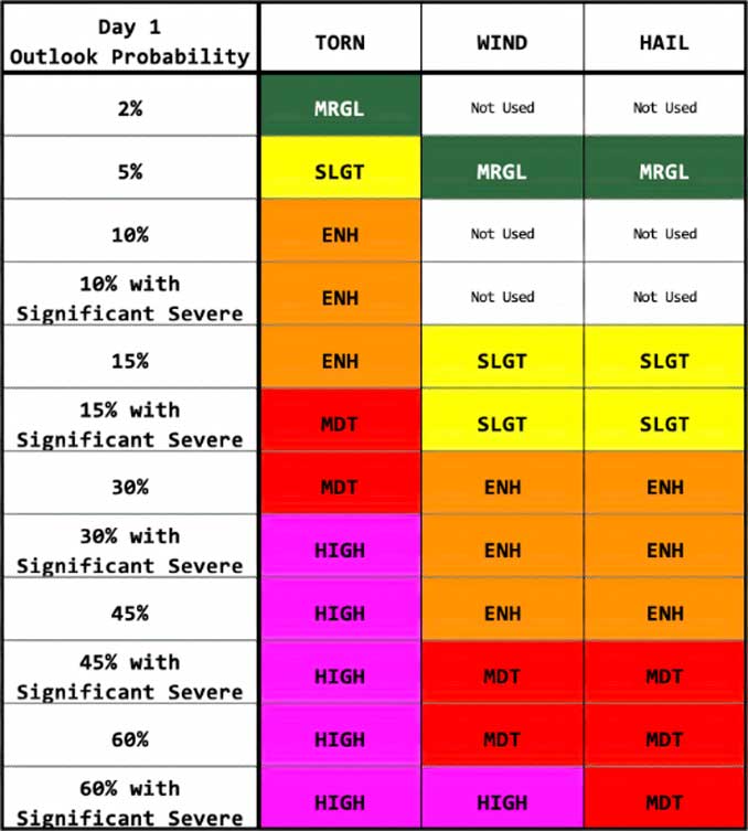
Tornado Outlook Defined
As part of the Day 1 Convective Outlook, the NWS Storm Prediction Center issues an SPC DAY 1 TORNADO OUTLOOK, usually covering a period of about 5 or more hours. A map shows zones where there is probability of a tornado within 25 miles within a point on the map. A Tornado Probability Legend indicates 2%, 5%, 10%, 15%, 30%, 45%, 60% and Significant probability. In Illinois, most outlooks are in the 2% to 5% range.