
Tornado Siren activation (now known as Outdoor Warning Siren Activation) caused considerable confusion Friday night, March 31, 2023 because there was no Tornado Warning activated by the National Weather Service for Arlington Heights when the sirens activated. Cell phone alerts for a Severe Thunderstorm Warning were activated about 7:52 p.m., and the Tornado Sirens or Outdoor Warning Sirens in Arlington Heights were activated beginning about 7:56 p.m.
There seems to be several issues that caused confusion. Alerts may be affecting people that aren’t actually in the severe weather area. People were confused about what the Outdoor Warning Siren actually means. What we have often known as the Tornado Siren might not only refer to a Tornado Warning anymore. Our community leaders have failed to clearly define this change in the meaning of the Outdoor Warning Siren to their communities because the Outdoor Warning Sirens also refer to other weather hazards.
According to Northwest Central Dispatch System (NWCDS) Executive Director John Ferraro, posting on the official Facebook page for NWCDS, “Some people believe that the sirens only get activated for a tornado warning, however, they also get activated for reported winds of 70mph or higher.” The truth is probably more accurately described as “most people” believe that the sirens only get activated for a Tornado Warning. Apparently, a lot of people didn’t get the memo that excessive thunderstorm winds also trigger an Outdoor Warning Siren activation. Then there’s the possible issue that 70+ MPH wind alert was not even applicable for Arlington Heights, where the sirens were activated. The NWCDS service area covers a number of communities that cover distances that can have significantly different severe weather conditions. While one community can have severe weather, another community might not have any severe weather at all. Apparently, we’ll need clarification regarding how NWCDS manages these differences.
When the sirens in Arlington Heights were activated five times, that really added to the confusion. Some people were confused that the second siren activation was an ‘all clear’ but then when three additional siren activations occurred, that sort of tossed the ‘all clear’ assumption. Ferraro explained on Facebook Friday night, “there is no ‘all clear’ for the sirens. They get activated every 10 minutes for the duration of the weather warning.”
It’s doubtful that many people knew about meaning of the repeat sirens every ten minutes for the duration of a weather warning. People that called or messaged CARDINAL NEWS, thought repeats were malfunctions, or ‘all clears’ followed by re-activations. People were also asking CARDINAL NEWS why there was a tornado siren activation when there is no Tornado Warning on any of the other common notifications. Judging the incoming messages at CARDINAL NEWS, the police desk switchboard and the 9-1-1 center (NWCDS) likely received numerous calls from concerned citizens, and that likely interfered with normal public safety communications operations.
Tornado sirens were activated in Arlington Heights five times between 7:56 p.m. and 8:36 p.m. Friday, March 31, 2023, signaling a Tornado Warning notification for the area, according to people’s ‘old school’ common understanding of “Tornado Sirens.” However, there were no Tornado Warnings activated for Arlington Heights Friday from any other sources that provide weather alerts. That lack of verification from multiple sources had people confused.
NWS Tornado Warnings are activated when there has been a tornado observed by trained weather spotters on the ground, or when Doppler radar indicates rotation within a storm that could spawn a tornado at any time. Neither of those two situations existed near Arlington Heights. Now we discover in the middle of severe weather that “Tornado Sirens” don’t correspond to just “Tornado Warnings, but the sirens are actually “Outdoor Warning Sirens” that are also activated for 70+ MPH winds.
“Tornado Sirens”, as they are commonly called, can be activated when a Severe Thunderstorm Warning is activated with the threat of large hail or thunderstorm winds that exceed 70 MPH, according to the NWS Quad Cities Office. It is currently unclear whether these 70+ MPH winds need to have been observed, reported, or indicated by imaging, such as radar, in order to trigger Tornado Sirens. Or whether a forecast that 70+ MPH winds are favorable, triggers Tornado Sirens. The latter doesn’t seem logical since conditions that indicate a tornado is possible trigger a Tornado Watch, not a Tornado Warning. But one might see how this could be extra confusing to the general public. Ferraro didn’t mention whether large hail was a qualifier for Outdoor Warning Siren activation as it is for Quad Cities.
In the City of Chicago, their outdoor warning sirens are “used to signify a major emergency or disaster, including a severe storm, tornado warning (not a tornado watch), earthquake, chemical hazard/hazardous material incident, extreme winds, biological hazard or event.”
Notice that the terms ‘severe storm’ and ‘extreme winds’ are vague compared to 70+ MPH thunderstorm winds. If the Outdoor Warning Siren would activate in an earthquake scenario in the City of Chicago, how many people would think the City of Chicago is about to get hit with a tornado immediately after an earthquake?
An increasing number of communities (including the Quad Cities area) are incorporating these wind and hail threats into their outdoor warning siren policies, according to the National Weather Service Office for the Quad Cities. Note the Quad Cities NWS Office called the sirens “Outdoor Warning Sirens.” We’re not sure that has been clarified or whether it applies here in northwest Cook County, except for tonight’s statements from John Ferraro.
Sirens are typically activated by city or county officials, usually a police or fire department or emergency management personnel. In Arlington Heights and nearby communities the sirens are activated by Northwest Central Dispatch System (NWCDS) — the regional 9-1-1 service.
According to the Quad Cities NWS Office, the local NWS office in the Quad Cities partnered with local emergency managers to develop the recommended siren guidelines that have since been adopted by many local communities. Nationwide, the National Weather Service does not recommend guidelines for sounding outdoor warning sirens, according to the Quad Cities NWS Office.
There was a Severe Thunderstorm Warning activated Friday night for an area in Chicagoland that included a threat of 90 MPH winds that was broadcast on NOAA Weather Radio, but this risk may have been well south of Arlington Heights (with Elk Grove Village furthest north in a list of Chicago neighborhoods and west and south suburban communities. The communities included Burbank, Carol Stream, Bolingbrook, Hinsdale, Oak Lawn, Oak Park, Oak Forest, Elmhurst, Bridgeport neighborhood in Chicago, Lincoln Park neighborhood in Chicago, Villa Park and others. Both Elk Grove Village and Arlington Heights are in the NWCDS service area. Actually, wind gusts were far short of 90 MPH in Arlington Heights. A preliminary look at wind gusts at O’Hare indicates wind gust were highest at about 52 MPH. A summary after 1:00 a.m. Sunday, April 1, 2023 confirmed that the “Highest Gust Speed” at O’Hare International Airport was 52 MPH from the west. At Chicago Executive Airport the “Highest Gust Speed” was 54 MPH. At Rockford the “Highest Gust Speed” was 58 MPH. The highest recorded gust speeds that were well south of Arlington Heights (where the NWS expressed greatest concern for south Chicagoland in their Area Forecast Discussion) occurred at Aurora (64 MPH), Midway (62 MPH), and Valparaiso, Indiana (75 MPH).
HIGHEST GUST SPEEDS …
Aurora … 64 MPH
Chicago Executive … 54 MPH
DuPage … 46 MPH
Midway … 62 MPH
O’Hare International … 52 MPH
Rockford … 58 MPH
Valparaiso IN … 75 MPH
Waukegan … 46 MPHSOURCE: NOAA/NWS Chicago
Climate Summary MAR 31 2023
There is also some doubt whether the NWS Chicago office ever expected 90 MPH gusts in thunderstorms near Arlington Heights. In their Area Forecast Discussion updated Friday March 31, 2023 at 8:38 p.m. the office seemed to be concerned with the severe winds east of I-55, far southern Cook County and eastern Will County.
The severe weather threat continues east of I-55 through around 10 PM. While the original quasi-linear convective system (QLCS) has weakened a smidge, the straight-line winds have regularly produced severe level gusts and continued scattered damage into the Chicago metro. Severe winds of 70+ mph remain favored. Also, the mesovortexgenesis threat continues for at least short-lived tornadoes, and seeing an area in far southern Cook County/eastern Will County that seems to be intersecting a boundary and/or interacting with some reflectivity tags that has had at least some circulation behavior. At the least, enhanced winds near 80 mph will be possible with this as it continues into Lake County Indiana and likely Porter County too.
— NWS Chicago 8:38 p.m.
In an earlier Severe Thunderstorm Warning for Arlington Heights at about 6:00 p.m. Friday, the NWS Chicago office warned of wind gusts of 60 MPH when the first of two rounds of thunderstorm lines passed through Arlington Heights at 6:18 p.m. The second round of thunderstorms passed through Arlington Heights beginning with rain at about 8:22 p.m. and wind gusts beginning about 8:33 p.m. Neither of the two thunderstorm rounds (6:18 p.m. and 8:22 p.m.) were impressive regarding severe weather, such as high winds, cloud-to-ground lightning, or hail. However, the first round brought heavy rain of more than an inch in Arlington Heights. NOAA Weather Radio reported some areas in Chicagoland observed 4 inches of rain.
It is unknown whether NWCDS was not given specific information about the location of the mention of 90 MPH wind gusts by the National Weather Service, or if NWCDS was given the appropriate information and it was mishandled by NWCDS.
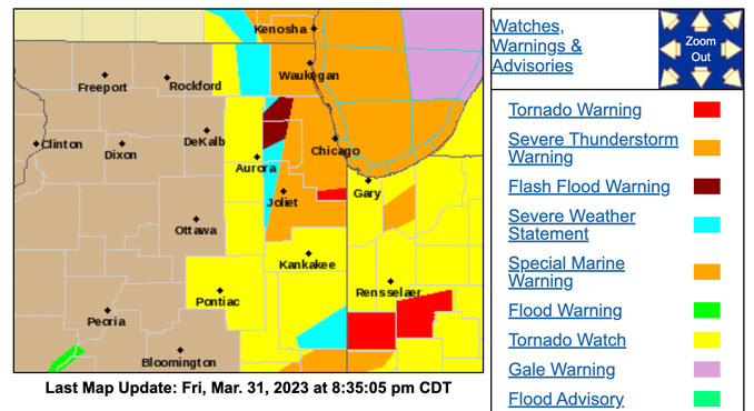
The five tornado siren activations occurred while the area was under the following hazardous weather alerts and advisories…
Tornado Watch
Severe Thunderstorm Warning
Flash Flood Warning
Flood Watch
Flood Warning
Wind Advisory
Northwest Central Dispatch provided explanation for the Outdoor Warning Sirens beginning at 8:26 p.m.
As of 8:30 p.m. the Village of Arlington Heights did not use social media to provide an explanation regarding the outdoor warning sirens on their official Facebook or Twitter accounts.
Also, the Arlington Heights Police Department did not provide a clarification of the outdoor warning siren activation on their official Facebook or Twitter accounts.
The Arlington Heights Fire Department does not have a known Facebook account, and does not have a known official Twitter account. The firefighters’ union Local 3105 has an official Facebook page, but the fire department apparently does not.
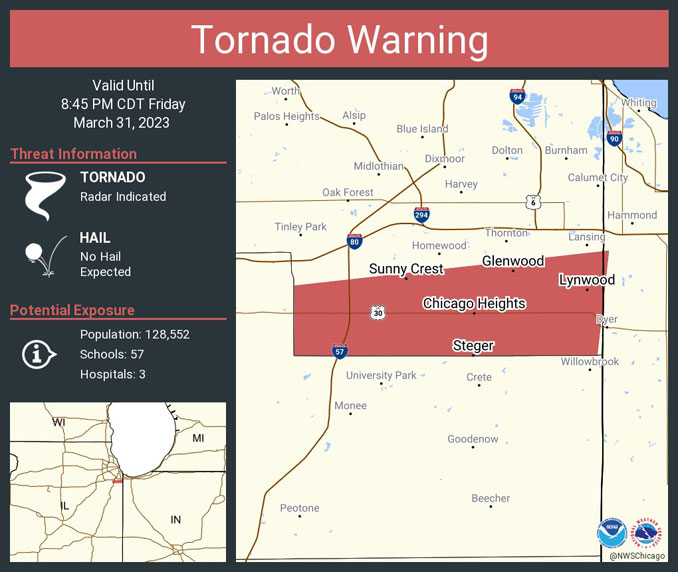
At 8:38 p.m. Friday, Comcast interrupted television programming in Arlington Heights, and displayed a Tornado Warning for Cook County, but this was a Tornado Warning for south Cook County that was activated for the area of communities including Chicago Heights, Glenwood, Lynwood, Richton Park, Steger, and Sunny Crest — over 40 miles away from Arlington Heights.
Tornado Warning including Chicago Heights IL, Park Forest IL and Matteson IL until 8:45 PM CDT pic.twitter.com/MBrzmeHQT1
— NWS Tornado (@NWStornado) April 1, 2023
Weather radar in the area showed a weakening thunderstorm line approaching Arlington Heights well before 8:00 p.m. The thunderstorm line passed through Arlington Heights associated with moderate wind gusts, infrequent lightning, and moderate rain from about 8:22 p.m. to 8:40 p.m.
As of 9:00 p.m. the Arlington Heights Fire Department only responded to one weather-related emergency call — an Activated Fire Alarm at the former Arlington Park grandstand located at 2200 West Euclid Avenue at 8:55 p.m. The Activated Fire Alarm is possibly related to a power disturbance, but the investigation of the facility and the alarm began when firefighters arrived by about 9:03 p.m. Firefighters on the scene reported at 9:07 p.m. that there was a power surge at the old grandstand that is believed to be associated with the Activated Fire Alarm.
At 9:13 p.m. there were six power outages in Arlington Heights reported by ComEd, and there was a significant outage involving 810 customers near Algonquin Road just east of Route 53. The trend of power outages affecting a small number of ComEd customers was increasing Friday night, but did was not excessive overnight.
At 9:10 p.m. there was an Activated Fire Alarm at Big Anges that was due to a power disturbance.
With the Wind Advisory overnight, wind gusts were expected to peak to around 45 MPH between 1:00 a.m. Friday and 8:00 a.m. Saturday with power disturbances associated with the high winds.
WEATHER RADAR
For LIVE Tornado Warnings for our area and the United States, see Arlingtoncardinal.com/tornadowarning or Twitter.com/NWStornado
Tornado Watch Defined
Be Prepared! Stay alert for possible Tornado Warning activations by tornado sirens, cellphone alerts, and news media alerts. Tornadoes are possible in and near the watch area. Review and discuss your emergency plans and check supplies and your safe room. Make sure cellphone batteries are charged and other important devices are properly equipped with fresh batteries. Be ready to act quickly if a warning is issued or you suspect a tornado is approaching. Acting early helps to save lives! Watches are issued by the Storm Prediction Center for counties where tornadoes may occur. The watch area is typically large, covering numerous counties or even states where a tornado or tornados may occur.
Tornado Warning Defined
A tornado has been sighted or indicated by weather radar. There is imminent danger to life and property. Move to an interior room on the lowest floor of a sturdy building. Avoid windows. If in a mobile home, a vehicle, or outdoors, move to the closest substantial shelter and protect yourself from flying debris. Warnings are issued by your local forecast office. Compared to a Tornado Watch, Tornado Warnings typically encompass a much smaller area (around the size of a city or small county) that may be impacted by a tornado identified by a forecaster on radar or by a trained spotter or law enforcement officer who is watching the storm.
NOTE: Tornado Warnings cover a precise area, but sometimes provide a very short warning time before a tornado strikes and causes harm. Even within the precise area, some areas may receive little damage; however tornados can make unpredictable turns within the precise area of a Tornado Warning.
Tornado Warning or Outdoor Warning Siren Defined
It depends on where you live.
^^ MOBILE? USE VOICE MIC ^^
facebook …
Please ‘LIKE’ the ‘Arlington Cardinal Page. See all of The Cardinal Facebook fan pages at Arlingtoncardinal.com/about/facebook …
Help fund The Cardinal Arlingtoncardinal.com/sponsor
THANKS FOR READING CARDINAL NEWS
Tornado Outlook Defined
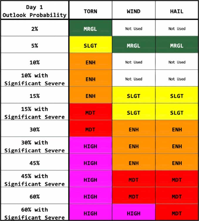
As part of the Day 1 Convective Outlook, the NWS Storm Prediction Center issues an SPC DAY 1 TORNADO OUTLOOK, usually covering a period of about 5 or more hours. A map shows zones where there is probability of a tornado within 25 miles within a point on the map. A Tornado Probability Legend indicates 2%, 5%, 10%, 15%, 30%, 45%, 60% and Significant probability. In Illinois, most outlooks are in the 2% to 5% range.
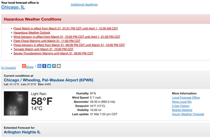
Flood Watch in effect from March 31, 07:01 PM CDT until April 1, 12:00 AM CDT
Wind Advisory in effect from March 31, 10:00 PM CDT until April 1, 01:00 PM CDT
Flash Flood Warning in effect from March 31, 07:09 PM CDT until March 31, 11:00 PM CDT
Tornado Watch in effect from March 31, 02:35 PM CDT until March 31, 10:00 PM CDT
Flood Advisory in effect from March 31, 06:09 PM CDT until March 31, 10:00 PM CDT
Severe Thunderstorm Warning in effect from March 31, 07:52 PM CDT until March 31, 09:00 PM CDT